Our journey to the North Cape
Verena Kaiser–Litschauer & Martin Litschauer
World spins as fast as we ride
Four weeks, two motorcycles, and the lonely roads of Finland and Norway. With great anticipation, lots of expectations, a trace of carelessness and endless thrills, we drove towards our big goal – the North Cape.
The ”loading master” called out to us at the freight terminal of Vienna’s Central Station: ”Heads down!”, and at walking speed we wobbled along the freight cars. We were reminded of the beginning of our Scotland trip, becoming more aware of the situation: ”It’s getting serious”. Both of us stood at the platform and watched how our motorcycles were lashed down, marking the beginning of our new adventure. With a gentle knock on
the cabin door we were woken up punctually at seven o’clock by the train attendant, arriving well rested in Hamburg-Altona and, as announced, the city welcomed us with bright sunshine. The port of Hamburg is one of the largest transhipment ports in the world and, together with its international airport, makes Hamburg one of the most important logistics locations in Europe. We already knew the city and therefore decided to have a leisurely breakfast in the port city. While enjoying a delicious crab-roll, we watched the many tourists on their way to the ”Miniatur Wunderland”, the largest model railway in the world. It was an outstandingly beautiful day and the screeching of the seagulls paired with the brisk life at the harbour created a holiday mood for the first time during this journey.
Already while planning our trip, we decided to take the ferry from Travemünde, 90 km away from Hamburg, to Helsinki. Therefore we relaxed the rest of the day at the promenade and stocked up on provisions for the next days. The engines of the Finnstar were already humming when the boarding started at midnight. We then crossed the Baltic Sea for the next two days.
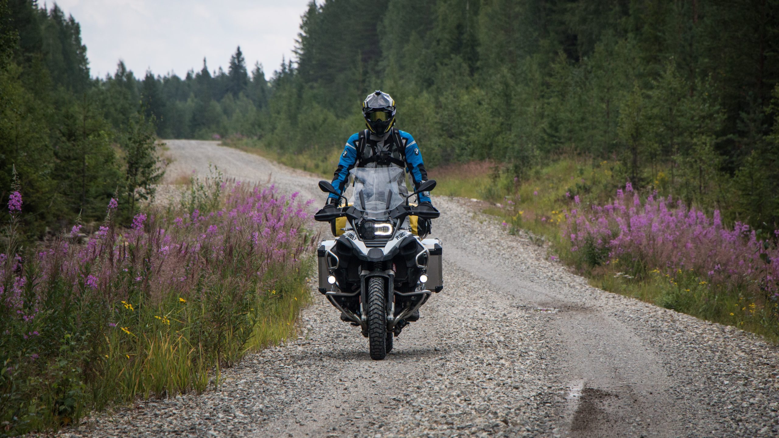
After about 35 hours and a distance of 611 nautical miles (1,132 km) we arrived in Helsinki. Looking at the LiveCamaboard the ship, we saw dark clouds and raindrops on the lens, preparing us to be harshly welcomed by the Scandinavian weather. After a few kilometres on smaller roads, we quickly left the capital of Finland and started the Trans Euro Trail, which follows about 2,200 km of small roads, often gravel, from Helsinki to the Norwegian border. We were facing the first off-road adventure of our lives. Once more, we carefully checked our luggage and went over the planned route together, before we set the board computer to ”Enduro” and covered the first kilometres on gravel. From now on we went towards one direction only: North!
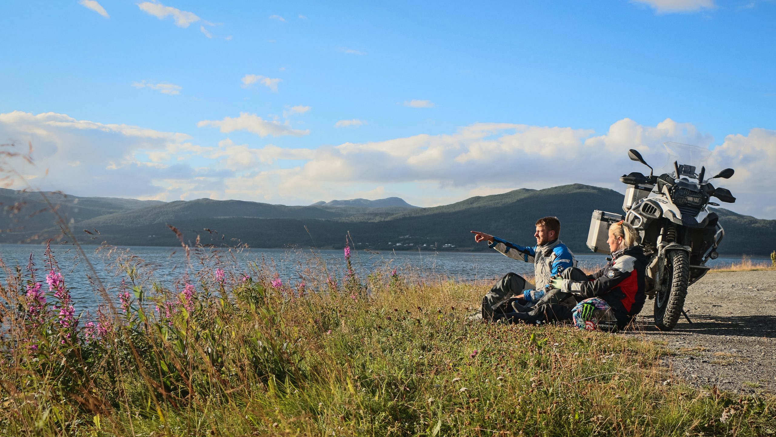
The city of Kouvola marks the beginning of the Finnish Lake District, arguably the most stereotypical part of the country with more than 180,000 bodies of water. The lake district, rich in moors and forests, is the largest of its kind in Europe, with an area of over 100,000 km2. In this area, it is really worthwhile to explore some of the smaller side roads that deviate from the TET, as numerous small bays, beaches and other hidden places by the water are waiting to be discovered. After the first 260 km through the unique landscape of Finland, we stopped in the town of Tommolansalmi and pitched our tent for the first time on a small but inviting campsite. It was already here, so early in the beginning of our trip, that we noticed the longer sun-hours compared to Austria during the same time of year. As with our last trips, we had quickly distributed the tasks for making camp and so our sleeping palace was ready in a few minutes. We noticed how much we have missed this daily ”travel routine”: setting up tents, getting into comfy clothes and being mesmerized by the landscape while sitting a camping chair with a self-cooked meal.
During beautiful days and blue skies, we scooted over countless gravel roads through the forests of Finland which impress with their untouched state. Speechless about the nature of the vast country, we arrived in Vuokatti after 350 km via Nurmes. We found a fantastic camp site at the lake – with bathing possibility! – and it happened for the first time on the trip, although some kilometers were still between us and the arctic circle, that the sun did not settle below the horizon. We were able to enjoy the sun at the jetty until 23 o’clock, before it hid behind a hill for a couple of hours.
The next section of traveling started along the Finnish/Russian border. Museums and old war materials remind of the warmore than 80 years ago in this area. Around the city of Suomussalmi, there was an attempt during the Second World War, to cut o? the Soviet Union’s transport connection from Finland to Sweden. With a slightly queasy feeling we started on the track, leading right through the historical terrain and forests, past the winter sports resorts Kuusamo and Rovaniemi. We had now arrived in famous Lapland, the land of reindeer and the midnight sun. Climate wise, Lapland goes into extremes: temperatures reach 30C? in summer and well below -30C? in the dark winters. Further north, it becomes an increased necessity to keep an eye on the fuel gauge, as the distances between the petrol stations are getting bigger and bigger. In Salla it is especially important to fill up the tank and stock up on fuel, because the next couple of hours on the bike are just tough – more than 300km without guaranteed access to petrol! After many kilometres, several photo stops and breaks, we decided to take a shortcut marked on the navigation system. At first, everything seemed to meet our expectations, but the joy soon came to a sudden end. Sand, mud, puddles and dirt roads forced us to turn around. 45 km one way o? road, and back again! Bathed in sweat and with nerves under maximum tension, but thankfully safe, we eventually reached an asphalt road again and in this exact moment, it was nothing more than the most beautiful thing in the world (sorry Verena, but i know you felt the same).
Exhausted and completely at the end of our strength, we finally arrived in Levi. Levi is the biggest and best known winter sports centre in Finland and has already been voted the best Finnish ski resort for four times. The ”Levi” mountain is just 531 metres high, but still a perfect destination for summer and winter excursions. We felt that it was time for us to have a motorcycle-free day, so we exchanged our motorcycle boots for our hiking boots and explored the surroundings of Levi on foot. Two years before, we had already waved our skis over the slopes here and putting into words how different the view and mood during winter and summer is, turns out to be almost impossible. In winter, the sun is rarely seen and even if it is, then only for what feels like a brief moment. In summer it is exactly the other way round, so we decided to go up the mountain for a midnight stroll and enjoy the sun. That was the absolutely best idea – the view was breathtakingly beautiful.
Around the arctic circle and further north, countless wildlife crossed our path and signs pointing to moose are not a rare sight either. Often, however, we caught ourselves just marvelling at the vastness of the landscape and paying far too little attention to the road. We know it is hard not to do so, but one has to be very careful, especially in summer – if there is one reindeer, its (also extended) family is never far. So it happened that we were surprised by a herd of reindeer making their way across the roads, seemingly unimpressed by the humming of our bikes. Marko, whom we met in Levi, told us that due to the many mosquitoes caused by the extreme heat, the plagued animals leave the forest and seek shelter along the roads. Especially in tunnels some extra attention is needed, as many of them seek shelter from the sun here.

Continuing on gravel, the trail led us to Hetta and from there, over the 93, to the Norwegian border – we successfully finished the Trans Euro Trail Finland! On the one hand we were happy to have made it, but on the other hand we were a little bummed, because we knew that the offroad driving we loved so much has come to an end. From now on it would continue mainly on asphalt roads. But another thing became clear as well: The North Cape is near! Along the E45, the landscape changed quickly and we found ourselves on a perfectly constructed road with optimal conditions. Past smaller lakes and rivers, the road winds through the hilly landscape up to the coast and the city of Alta. From here it was only 240 km to the North Cape, though the next section starts with a barren landscape and a dead straight road. But from Olderfjord, on the E69, one gets compensated with 128km of unbelievable coastal views.
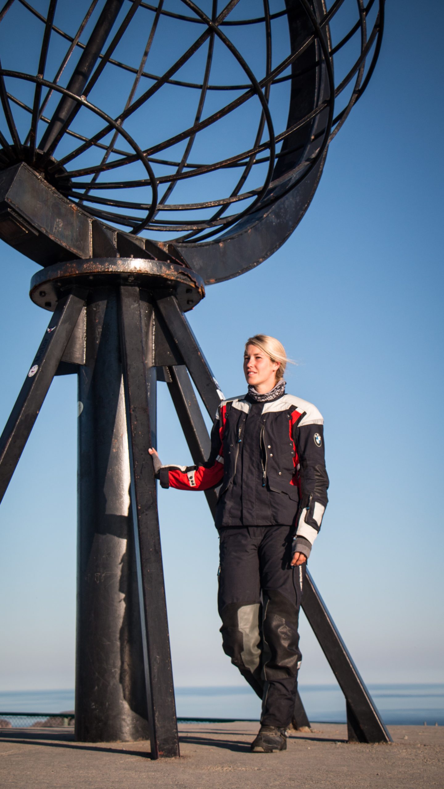
Finally – we were very close to our long-cherished wish! Around noon we reached our destination: The North Cape! Our mood was unique, so long we dreamed of reaching this point with our motorcycles and now it was finally there. The landscape is mostly hilly and to the left and right of the well-developed road you can see countless reindeer making their rounds. Along the route there are plenty of parking spots and viewpoints from which you can start one of the several hiking tours. Arriving at the gate, we bought two day-tickets for 27e each, so we now had 24 hours access to the different offers in the North Cape area: souvenir shop, cinema, chapel, museum and a restaurant. The parking lot was only half full and we were able to enjoy the great atmosphere in peace. We could hardly believe our luck, a really special moment for both of us. Only a quarter of an hour away we pitched our tent at the northernmost campsite in the world: Kirkeporten Camping. For us the perfect starting point for our tours planned for the next two days, including the absolute highlight: the hike to the headland Knivskjelodden. This point is about 1.5 kilometersfurther north than the North Cape, making it the actual northern endpoint of mainland Europe. The hike is quite long with 19 km, but not difficult or dangerous. The view onto the 307 meter high North Cape Plateau is breathtaking when the weather is allowing it. What could not be missing of course, was a photo with our motorcycles in front of the landmark of the North Cape, the globe. The only issue was, that as long as the gate and the buildings are opened, it is not allowed to drive up to the globe. Only from 01:00 o’clock to approx. 06:00 o’clock in the morning, one has the possibility to take his personal memory photo. Of course we used this chance and it marked the crowning finale of our adventure ”North Cape”.
The following morning, the sun turned our tent in to a sauna by 6 o’clock and so we quickly packed our stuff and headed south. With a laughing and crying eye we said goodbye to the North Cape and decided to drive to Tromsø on this day. The roads were as good as empty and not only the reindeer enjoyed the cool air along the coast, when Martin suddenly roared through his communication system: ”Verena! Whales!” What a spectacle! A herd of pilot whales was circling peacefully about 100 meters o? the coast. The water was as smooth as glass and we could observe them undisturbed for several minutes before they dove into the blue ocean again.
Shortly before we reached Tromsø we used the first rather small ferry during our trip. Who would have thought that the waves, which can be bought in front of almost every ferry, would quickly become part of our daily ritual? They are unexpectedly amazing! Tickets were quickly and easily paid by credit card and a parking space was allocated by the helpful staff, so we could move to deck and enjoy the fresh breeze. We felt more like on a ferry to Greece or Italy, watching a group of teenagers dressed in swimming trunks and Flip-Flops enjoying the summer. We on the other hand, almost melted away in our thick motorcycle robes.
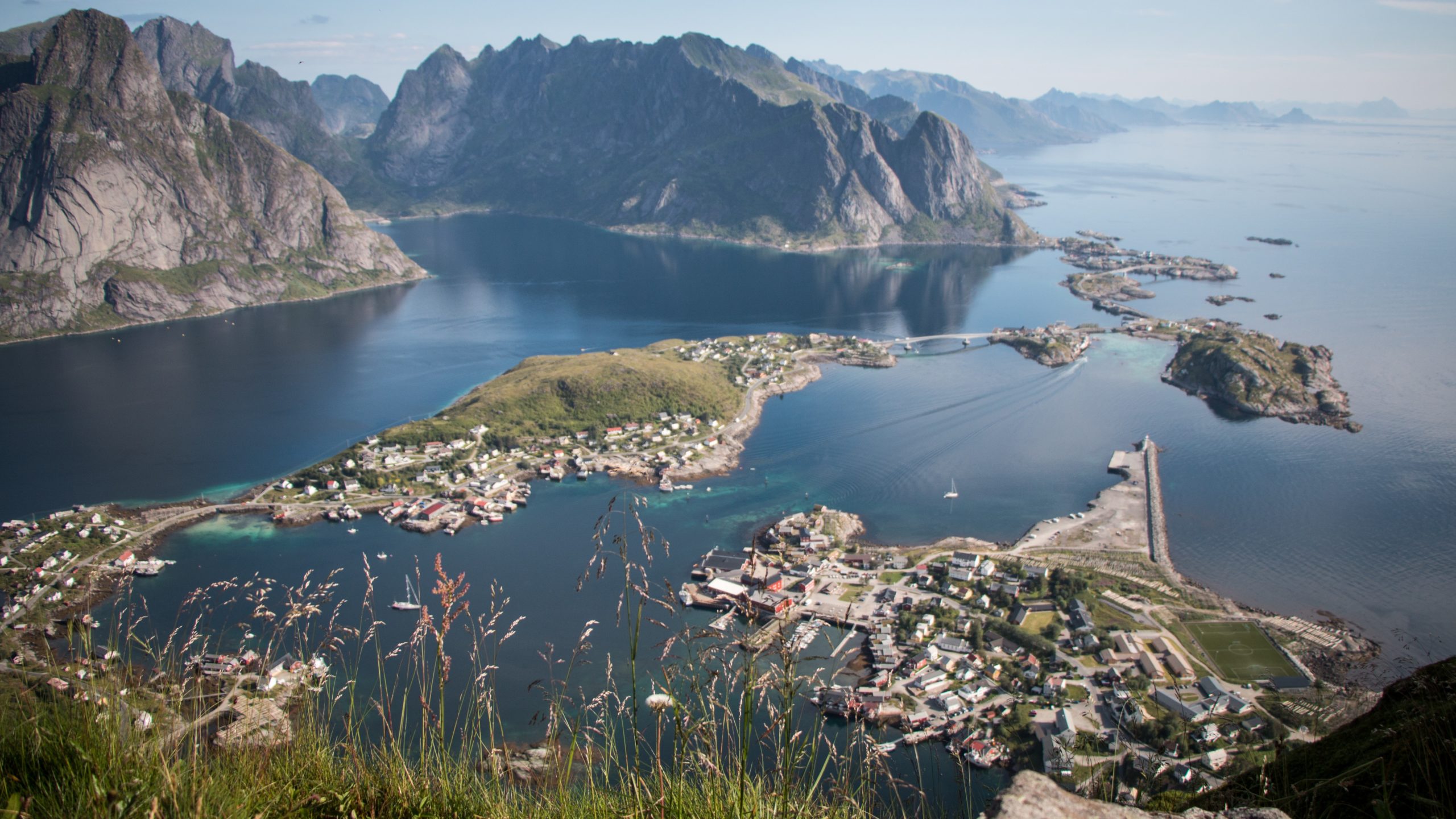
Along the E8 and E10 we finally came to the archipelago of the Lofoten. 80 islands, the largest of which are connected by bridges or tunnels, build one of the most visited areas of Norway – for a reason. The contrast between mountains over 1200 meters high and the sea is breathtaking. Charming fishing huts and the curved streets conjure up a smile under the helmet. Passing Evenskjer, Svolvaer and Heeningsvaer we pitched our tent in Moskenes at the end of today’s pitch, directly at the ferry port on a cosy camp site. You could easily spend two weeks on the islands alone, because behind every bend a new postcard motive is waiting for you. Friends adviced us to undertake a hike on the Reinebringen. The view from the 442 metre high peak on the village of Reine is one of the most iconic in Lofoten. The trail leads partly very steeply over boulders and boggy, earthy, partly muddy or with roots overgrown underground, as well as past intimidating cli? edges. For this reason, the tour should only be done in dry weather. The last ascent before the peak was quite exhausting and we were considerably out of breath, but the view was worth it a thousand times!
On the day of our departure from Lofoten, the loud screaming of the seagulls interrupted our slumber. As we opened the tent, we mentioned how a fishing boat just returned to the harbour, having lots of hungry seagulls in tow. Punctually at 8 o’clock, our ferry left and we enjoyed a last glimpse on the islands from the ship. Arriving in Bodø, we were already looking forward to the next section. When we unloaded the motorcycles in Hamburg-Altona, we got to know Loke and his Honda CBR 125 who gave us the tip not to drive on the E6, but to take the smaller FV17 to Steinkjer. The route was longer, but the wonderful view along this route quickly convinced us that we had made the right decision. The road leads through the landscapes of Namdalen, Helgeland and Salten. Numerous tunnels and six ferries are needed until 650 km and the Arctic Circle are crossed. The last kilometres on the E6 before Trondheim turned out to be harder than expected and we were happy to finally reach the campsite through unusual city traffic. We arrived in the early afternoon we and decided to explore the city on foot. The canal port delimits the inner-city peninsula to the north. It was created in the middle of the 19th century as part of a new harbour plan for the city. On the south side of the ”Kanalhavna” you will see a number of typical Trondheim warehouses which are located directly at the water. In the centre of the city there is a marketplace where a huge streetfood festival took place. Since the route at the FV17 was again very sparsely populated and we had hardly met any people the last days, we enjoyed the colourful hustle and bustle and even more, the delicacies ordered here from all over Norway and the rest of Scandinavia.
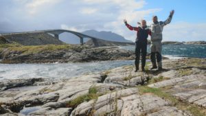
The Atlanterhavsvegen, Norway’s most famous road, measures exactly 8274 metres. This road was also a must on our trip. Due to its course with eight bridges over several small islands, it made itself a name as a popular tourist attraction. Especially famous is the Storseisundbrua, known for its unusual curved shape. With a length of 260 metres and a height of 23 metres, it is the largest bridge of the Atlantic Road built in the 1980s and at the same time its landmark.
The Trollstigen was still dipped in the fog as we approached from Andalsnes, but the road, opened in 1936, soon showed its best side. Even today it is only a few metres wide, sometimes almost single-laned, so that you have to avoid oncoming vehicles. Because of the rugged terrain, there are hardly any possibilities to stop. Since we were already there very early, we did not miss the chance to simply stop on the road, shooting a few very impressive photos. Also a visit in the visitor centre ”Trollstigen Fjellstue” is highly recommended. From there you can enjoy the viewpoints around the car park.
We now followed road 63 to the south. Past the Talfjord a breathtaking panorama to the Geiranger Fjord opened up to the. It is one of the most beautiful fjords in Norway and is part of the UNESCO world natural heritage. Its unique natural diversity and the impressive symbiosis of sea and high mountains make it something truly special. We were lucky and could watch one of the huge cruise ships mooring – the manoeuvre of such a gigantic ship is impressive, and even more so to watch from up close. But we didn’t think about the masses of tourists in the village just a few minutes later and so we decided to continue to the mountain top of Dalsnibba at 1476 meters. The trip there was exhausting as many tourist buses crossed out way and for a short time, we even thought about turning back. But the view from the summit again compensated us for the arduous journey. From up here one has a grandiose view into the Geirangerfjord that is approximately 7 kilometres away.
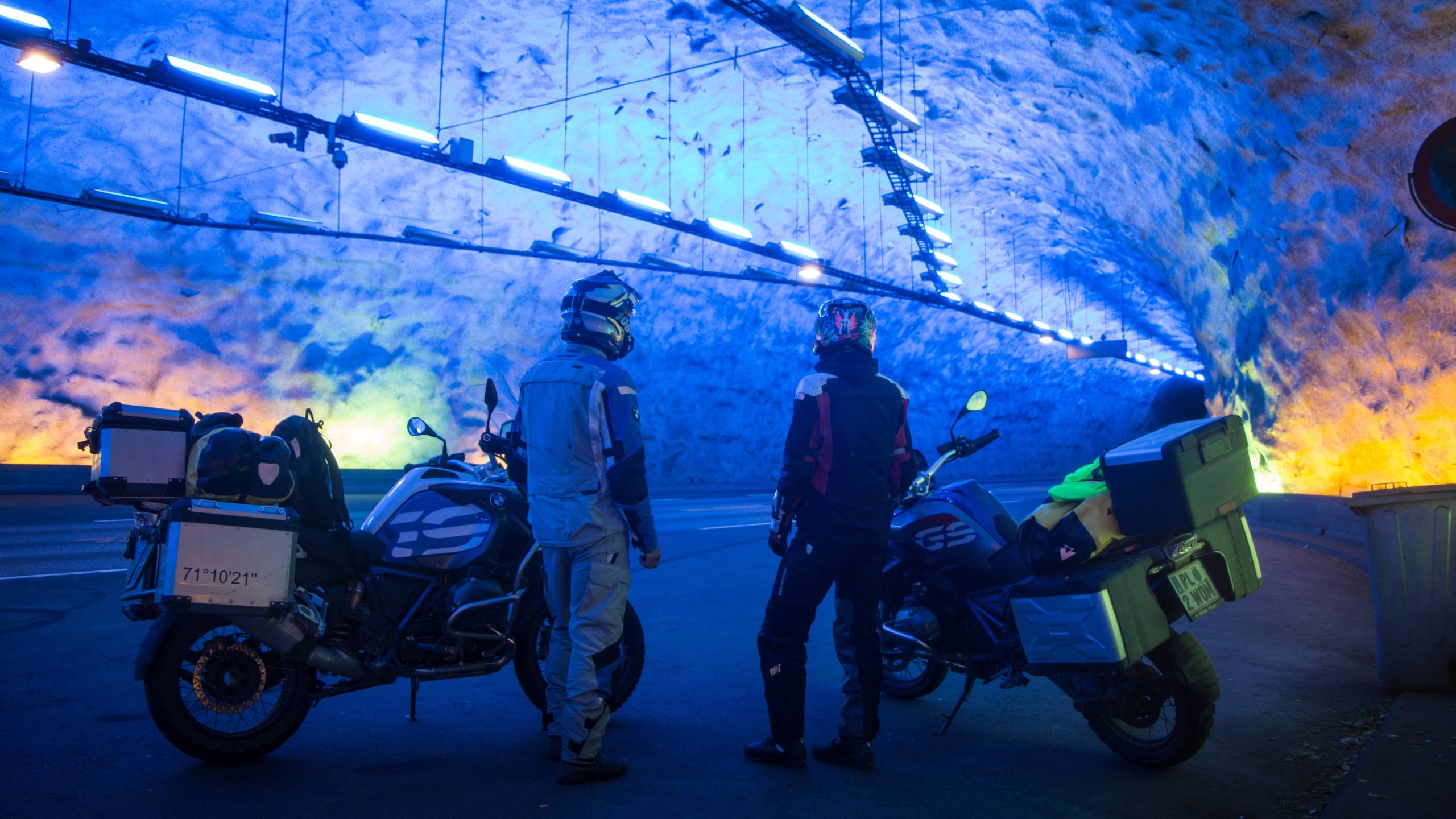
We continued along the Otta river, where we drove again and again on the main road 15 and onto the small side roads Fv485 and Fv483. At Fossbergom we headed south on the 55, towards our next destination, Trolltunga. The horizontal rock ledge is a very popular photo motive for tourists. Unfortunately, the weather forecast for the next days did not look too good and since the 28 km long approach is partly very demanding, we decided to pass on this spot. the next highlight was not long in coming anyway: the longest road tunnel in the world! The Lærdalstunnel connects Aurland and Lærdalsøyri with its 24,51 km. The construction took 5 years and is free for motorcyclists to cross. The special features of this tunnel are the innovative type of lighting and the deliberately slightly winding route, both of which are intended to protect riders from fatigue and promote concentration.
We decided to take advantage of the good weather in the south and drove on to Jørpeland. This place is the starting point for many tourists who want to visit the Preikestolen and so we pitched our tent on the camping site only a few kilometres away. Already at 03:00 o’clock our alarm clock rang. Tired we crawled into our hiking clothes and out of the tent to start the from the deserted parking lot at dawn. The four kilometre long path is very well constructed and leads first steeply up a ridge and then almost evenly over plank paths through swampy forest. After about an hour we reached the unsecured platform of the ”sermon chair”. Only a few people, including those who had spent the night up here, enjoyed the almost uncanny silence and watched the sunrise. An almost meditative atmosphere made this moment of the first rays of sunshine something rememberable. The view into the sunny Lysefjord is as stunning as it can get and belongs to one of the highlights of our trip. When we started our way home, the most famous sight of Norway showed itself from a completely different side. Masses of tourists fought their way over the hiking trail to the summit. Now we realised that the pictures of tourist masses are no exaggeration and were relieved that we had already left at sleeping hour.
We spent the next two days in Oslo, the capital of Norway. In the beginning we wanted to take a hotel room as a reward for our ”exertions”, but then we couldn’t resist the charm of the Ekeberg camping site. The location of this campsite offers a fantastic view over the whole of Oslo. We pitched our tent here for the remaining time of our trip and in great weather, we used the last days for extensive sightseeing. Numerous sights, like the opera, the ski jump Holmenkollbakken and the ski museum, give the city its ?air. The ski jump stands on a slope of Holmenkollen and is considered the oldest ski jump in the world. In good weather conditions it also offers an excellent view over the capital. We will remember Oslo as a modern, progressive and lively city.
The sun was greeting us on our day of departure. The seagulls screeched and with the roar of the big diesel engines of the ColorLine, a slightly melancholic mood arose in us. We enjoyed the cool sea breeze one last time and let the many wonderful moments of our journey run through our minds.
